by bburgeson
Share

Satellite imagery can be a useful tool for making agronomic observations related to irrigation during the growing season. Crops will show vegetative differences which are seen in satellite imagery layers due to localized growing conditions within the field influenced by irrigation.
The variability in vegetation can sometimes be hard to observe and monitor consistently in person to ensure that plant health is optimized everywhere. Crop height and canopy closure, elevation, accessibility, and managing large acres can often make irrigation system management more challenging.
When irrigation systems are not performing as expected for various reasons, correcting the issue(s) as quickly as possible can sometimes make the difference between crop success or crop failure – or at least a significant difference in grain or forage yield production. As a complement to rigorous in-field crop scouting – satellite imagery can help detect performance issues and irrigation management decisions can be made more responsively.
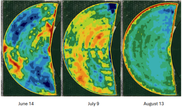
See the three NDVI (vegetative index) satellite images below on a field which highlight both in-field variability and variability over a 3-month period during the 2024 growing season. Due to the shape and distribution patterns – much of the variability can be correlated to irrigation system performance.

Leveraging satellite imagery as a complementary tool with timely and consistent in-field scouting observations creates value by increasing your ability to confidently manage irrigation equipment and strategies. All of our VRAFY service levels include satellite imagery layers which can be easily viewed on your phone or tablet through the John Deere Operations Center™ Mobile App to help with investigating or confirming crop performance in specific spots while in the field – in real time and with confidence. Make sure you’re leveraging your VRAFY investment to help manage irrigation more effectively with satellite imagery.

